Thursday saw another drop of open data with 30 million addresses from DSIT/BDUK and we have now added that to our broadband maps and also made the information visible if people click an address at the higher resolutions.
The latest data on Thursday gives everyone insight into the status of their address in terms of Gigabit coverage both current and planned, at least so far as data has been submitted through the Open Market Review process. The key part for those wondering about whether they will get service via a Project Gigabit contract or be left waiting for the next wave of contracts is that the project scope is included at the address level, along with indications of possible suppliers.
The data is from September 2024, so things like Gigabit status will have changed for lots of addresses and also Project Gigabit status may have changed. Data updates should be published every 4 months i.e. three times a year.
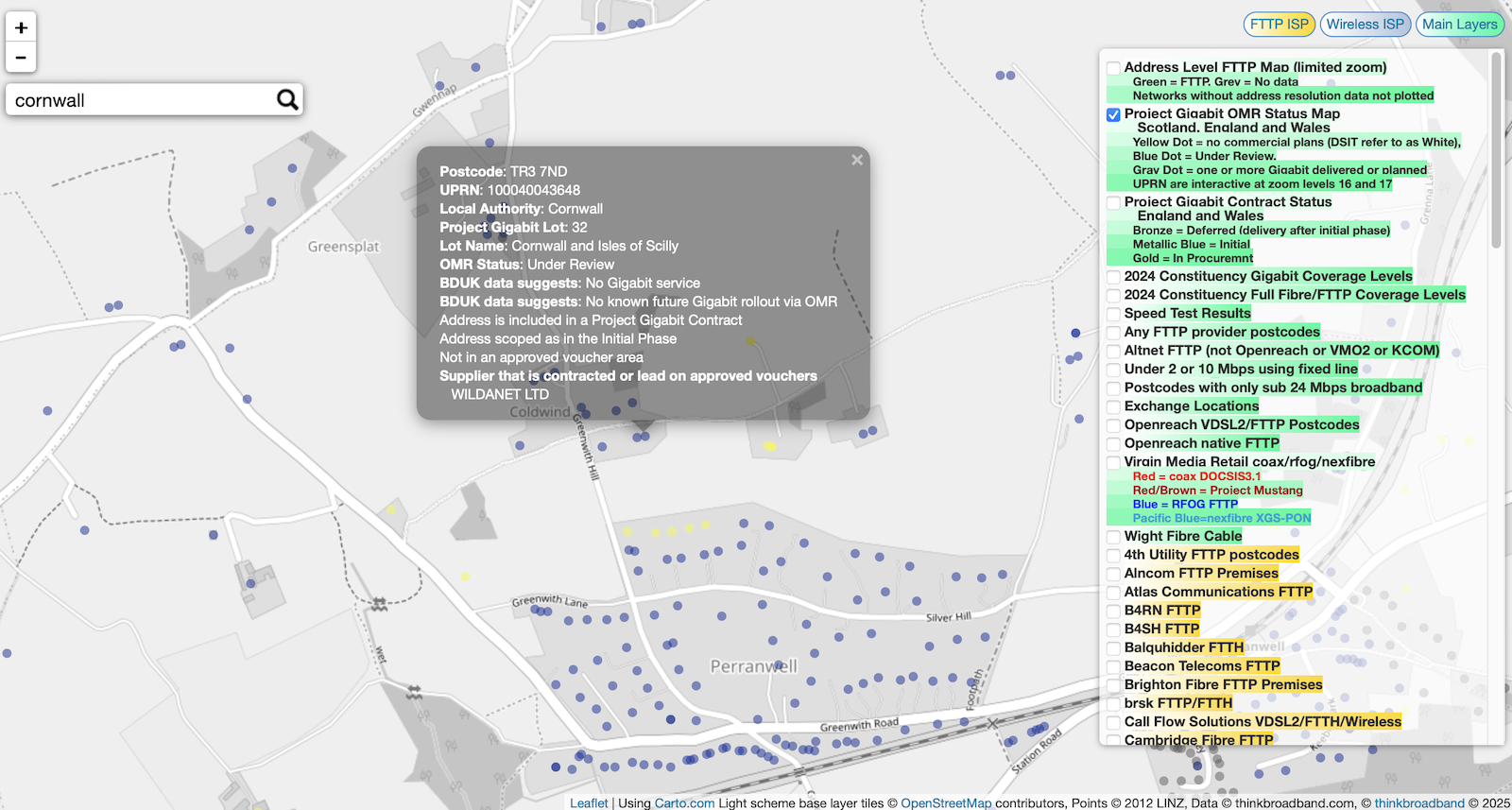
Example of DSIT/BDUK information available for addresses on our broadband map
The interactivity is currently available only if viewing the Project Gigabit OMR Status Map layer on our maps. We have a render also of the Project Gigabit Contract Status since and this shows just addresses where the contract status is In Procurement, Deferred or Initial. The reason for showing this subset is that it gives a clearly defined subset for where Project Gigabit subsidised rollouts are expected. In terms of figures the addresses with a contract status is 1,135,490 from a dataset of 30.8 million addresses across England and Wales.
 Test your broadband speed
 Follow us on X for the latest broadband news


Thanks for integrating this data.
Technical question: the key states that UPRN data is interactive at zoom levels 16&17. How does the user know what zoom level they are at, other than by trial and error? It doesn’t appear to be the most zoomed in level (unless my browser was misbehaving).
Ahh, I see it’s in the URL (partially hidden in Safari). I assume that the interactivity requires a pointing device?
The map is great but I can only see the colours of dark blue and a rather muddy orange. Does the orange represent the gold and and bronze categories combined or are these two “orange” looking categories intended to appear different? If so, would it be easier to show a difference using a higher level of zoom or (if that is not practical) by using colours with a higher level of discrimination?
Good point on knowing the zoom level – will add a message for when map is interactive.
Pointing device – tested interactive on iOS and it works using a finger.
On Farthings question…can you post the url for where you are looking at, will help understand issue. An address/uprn cannot be two categories, but some lat/lng do have multiple addresses that stack precisely so may give a combined colour effect.
NOTE: If showing multiple address layers you can have a stacked colour effect obviously.
Thanks. Here is the URL: https://labs.thinkbroadband.com/local/broadband-map#14/52.5316/1.1781/bduk/ I only have this single layer turned on so there are no stacked colour issues. So are the orange dots I’m looking at gold or bronze? If both are included on this page then my 24 inch 2560×1440 ASUS display can’t discriminate between them.
@farthing – that link you posted has a different layer enabled. You have the ‘Project Gigabit Contract Status England and Wales’ layer enabled, try the ‘Project Gigabit OMR Status Map Scotland, England and Wales’ layer instead.
Nice work.
If this is from Sep and its updated 3 times a year when is the next drop due?
Those dots are bronze.
Only 6,082 Gold postcodes across England and Wales example https://labs.thinkbroadband.com/local/broadband-map#13/52.5215/-2.9131/bduk/
https://labs.thinkbroadband.com/local/broadband-map#8/52.656/-1.154/bduk/ you can see the gold is lighter compared to bronze on this zoomed out view.
Next update is expected in May, which is to be based on data submitted in January.
Moved to a new build area where OFNL is the sole network provider, so, good to see there’s a layer for the data now!
Side note: My specific ISP ‘LinkBroadbands’ still is not in the listings along with others, although their name will be changing soon anyway to ‘Rocket Fibre’ from April.
Not a criticism, as many are not well-established yet plus most will not resolve to IP blocks owned by OFNL nor the ISPs themselves for auto-identification to work unless the customer has static IP add on.
Andrew: thank you for confirming the majority of dots (the ones which are not blue) are bronze. Over the weekend, I worked through the huge CSV database for our region. I was then able to select all our village postcodes from the list – and all the Project Gigabit properties were all marked “deferred”. At that point, the penny dropped that we didn’t have any gold ones and that those were probably scarce.
It goes without saying that these new listings are a brilliant resource and it will be interesting to see how it evolves over time.
when is the next update on this map and data? 17-12-25
The OMR Project Gigabit layer is reliant on the Open Data being released by BDUK this last appeared in September so with their cycle of three updates a year expect to see data again in January or February 2026